Saturday 14 December 2013

Afghanistan

Yeah, just a couple of cards again for today. This one's pretty special as well, my first postcard from Afghanistan, although not mailed using Afghan stamps but mailed from a US army base. Still, I'm really happy to have this one in my collection, and it's a Unesco card as well! :) Thank you so much for the swap, Jon!


Afghanistan, officially the Islamic Republic of Afghanistan, is a landlocked sovereign state forming part of South Asia, Central Asia, and to some extent Western Asia. It has a population of around 30 million inhabiting an area of approximately 647,500 km2, making it the 42nd most populous and 41st largest nation in the world. It is bordered by Pakistan in the south and the east, Iran in the west, Turkmenistan, Uzbekistan, and Tajikistan in the north, and China in the far northeast.

Afghanistan has been an ancient focal point of the Silk Road and human migration. Archaeologists have found evidence of human habitation from as far back as the Middle Paleolithic. Urban civilization may have begun in the area as early as 3,000 to 2,000 BC. Sitting at an important geostrategic location that connects the Middle East culture with Central Asia and the Indian subcontinent, the land has been home to various peoples through the ages and witnessed many military campaigns, notably by Alexander the Great, Arab Muslims, Genghis Khan, and in modern era Western forces. The land also served as a source from which the Kushans, Hephthalites, Samanids, Ghaznavids, Ghorids, Mughals, Durranis and others have risen to form major empires.

The political history of the modern state of Afghanistan begins in 1709 with the rise of the Pashtuns, when the Hotaki dynasty was established in Kandahar followed by the rise of the Durrani Empire in 1747. In the late 19th century, Afghanistan became a buffer state in the "Great Game" between British India and the Russian Empire. Following the 1919 Anglo-Afghan War, King Amanullah began a European style modernization of the country but was stopped by ultra-conservatives. During the Cold War, after the withdrawal of the British from neighboring India in 1947, the United States and the Soviet Union began spreading influences in Afghanistan, which led in 1979 to a bloody war between the US-backed mujahideen forces and the Soviet-backed Afghan government in which over a million Afghans lost their lives. This was followed by a 1990s civil war, the rise and fall of the extremist Taliban government, and the 2001–present war. In December 2001, the United Nations Security Council authorized the creation of the International Security Assistance Force (ISAF) to help maintain security in Afghanistan and assist the Karzai administration.

 Three decades of war made Afghanistan one of the world's most dangerous countries. While the international community is rebuilding war-torn Afghanistan, terrorist groups such as the Haqqani Network and Hezbi Islami are actively involved in a nationwide Taliban-led insurgency, which includes hundreds of assassinations and suicide attacks. According to the United Nations, the insurgents were responsible for 80% of civilian casualties in 2011 and 2012.

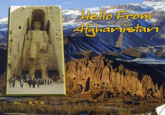
As for this postcard, it shows the Cultural Landscape and Archaeological Remains of the Bamiyan Valley. Ignoring an international outcry, the Taliban began demolishing statues across the country in 2001, including two towering ancient stone Buddhas. Militiamen virtually destroyed the almost 2,000-year-old Buddhist masterpieces in the central province of Bamiyan, including the world's tallest standing Buddha measuring 50 metres.

Bulgaria

Time for another wee post, long overdue again. Oops.. I received this beautiful card from dear Snježana earlier this year from her holiday in Bulgaria. It must be lovely there!


Bulgaria, officially the Republic of Bulgaria, is a country located in Southeastern Europe. It is bordered by Romania to the north, Serbia and Macedonia to the west, Greece and Turkey to the south, and the Black Sea to the east. With a territory of 110,994 square kilometres, Bulgaria is Europe's 14th-largest country.

Organised Prehistoric cultures began developing on Bulgarian lands during the Neolithic period. Its ancient history saw the presence of the Thracians, and later the Greeks and Romans. The emergence of a unified Bulgarian state dates back to the establishment of the First Bulgarian Empire in 681 CE, which dominated most of the Balkans and functioned as a cultural hub for Slavic peoples during the Middle Ages. With the downfall of the Second Bulgarian Empire in 1396, its territories came under Ottoman rule for nearly five centuries. The Russo-Turkish War of 1877–1878 led to the formation of the Third Bulgarian State. The following years saw several conflicts with its neighbours, which prompted Bulgaria to align with Germany in both World Wars. In 1946 it became a single-party Socialist state as part of the Soviet-led Eastern Bloc. In 1989 the ruling Communist Party allowed multi-party elections, which subsequently led to Bulgaria's transition into a democracy and a market-based economy.

Bulgaria's population of 7.36 million people is predominantly urbanised and mainly concentrated in the administrative centres of its 28 provinces. Most commercial and cultural activities are centered on the capital and largest city, Sofia. The strongest sectors of the economy are heavy industry, power engineering, and agriculture, all of which rely on local natural resources.

Monday 11 November 2013

Benin

The second and last card for today :P It's a new country to my collection as well, and one of the few postcards I have from Africa. Thank you a million, Johanna! I love markets views as well so this card is pretty much perfect :)


Benin is a country in West Africa. It is bordered by Togo to the west, by Nigeria to the east and by Burkina Faso and Niger to the north. A majority of the population live on its small southern coastline on the Bight of Benin. The capital of Benin is Porto-Novo, but the seat of government is in Cotonou, the country's largest city. Benin covers an area of approximately 110,000 square kilometers, with a population of approximately 9.05 million. Benin is a tropical, sub-Saharan nation, highly dependent on agriculture, with substantial employment and income arising from subsistence farming.

The official language of Benin is French. However, indigenous languages such as Fon and Yoruba are commonly spoken. The largest religious group in Benin is Roman Catholicism, followed closely by Islam, Vodun and Protestantism. Benin is a member of the United Nations, the African Union, the Organisation of Islamic Cooperation, South Atlantic Peace and Cooperation Zone, La Francophonie, the Community of Sahel-Saharan States, the African Petroleum Producers Association and the Niger Basin Authority.

From the 17th to the 19th century, the main political entities in the area were the Kingdom of Dahomey along with the city-state of Porto-Novo and a large area with many different tribes to the north. This region was referred to as the Slave Coast from as early as the 17th century due to the large number of slaves shipped to the New World during the Trans-Atlantic slave trade. After slavery was abolished, France took over the country and renamed it French Dahomey. In 1960, Dahomey gained full independence from France, and had a tumultuous period with many different democratic governments, many military coups and military governments.

 A Marxist-Leninist state called the People's Republic of Benin existed between 1972 and 1990. In 1991, it was replaced by the current multi-party Republic of Benin.

Shau Kei Wan Road, Shau Kei Wan, Hong Kong

Just a very small update for today... starting with this lovely card from Hong Kong that I received earlier this year.


A Hello Kitty tram! :D Apparently they are not very common, or at least that's what Vince who sent me this card told me.

 Shau Kei Wan is a town in The Eastern District, located in the north east of Hong Kong Island. Literally, Shau Kei means a pail, and Wan implies that the town is developed along the coast. Nowadays it is a relatively densely populated town compared with some developing areas.

Saturday 12 October 2013

Guadeloupe

One more card for today... a fantastic market view from Guadeloupe. Thank you a million, Olga!


Guadeloupe is a Caribbean island located in the Leeward Islands, in the Lesser Antilles, with a land area of 1,628 square kilometres and a population of 400,000. It is an overseas region of France, consisting of a single overseas department. Guadeloupe is an integral part of France, as are the other overseas departments. Besides Guadeloupe island, the smaller islands of Marie-Galante, La Désirade, and the Îles des Saintes are included in Guadeloupe.

As part of France, Guadeloupe is part of the European Union and the Eurozone; hence, as for all Eurozone countries, its currency is the euro. However, as an overseas department, Guadeloupe is not part of the Schengen Area. The prefecture (i.e. French regional capital) of Guadeloupe is Basse-Terre. Its official language is French, although many of its inhabitants also speak Antillean Creole (Créole Guadeloupéen).

Olga tells me that traditional markets like the one on this postcard are very popular in Guadeloupe and offer the biggest choice of fruits and vegetables. There are only 4 big supermarkets in the islands!


French stamps are used in Guadeloupe.

South Korea

A fantastic map card I received from a swap last year. I'd been hoping to receive this card for quite some time so I'm really happy to finally have a copy.


South Korea, officially the Republic of Korea, is a country in East Asia, constituting the southern part of the Korean Peninsula. It shares land borders with North Korea to the north, and oversea borders with China to the west and Japan to the east. South Korea lies in the north temperate zone with a predominantly mountainous terrain. It comprises an estimated 50 million residents distributed over 99,392 km2. The capital and largest city is Seoul, with a population of 10 million.

South Korea is a presidential republic consisting of 17 administrative divisions and is a developed country with a very high standard of living. It is Asia's fourth largest economy and the world's 15th (nominal) or 12th (purchasing power parity) largest economy. The economy is export-driven, with production focusing on electronics, automobiles, ships, machinery, petrochemicals and robotics. South Korea is a member of the United Nations, WTO, and OECD, and a founding member of APEC and the East Asia Summit.


I collect Chinese New Year stamps so I was really happy to see the stamp on the top. It's supposed to glow in the dark, too, but I haven't tried that yet...

Fes, Morocco

This postcard is from a swap with Najma in Morocco. We swapped a couple of cards last year and the year before, I believe I've posted the other one here as well...


This card shows a view from the Mnebhi Palace in Fes, Morocco. Fes or Fez is the third largest city of Morocco, with a population of approximately 1 million (2010). It is the capital of the Fès-Boulemane region.

The city has two old medinas, the larger of the which is Fes el Bali. It is listed as a UNESCO World Heritage Site and is believed to be one of the world's largest car-free urban areas. Al-Qarawiyyin, founded in AD 859, is the oldest continuously functioning madrasa in the world. The city has been called the "Mecca of the West" and the "Athens of Africa".

Ampelmännchen, Berlin, Germany

When I got back home from Benidorm I had a lot more mail waiting for me than I had expected, which I thought was odd. Turned out I was lucky enough to be the 'Winner of the Month' for September 2013! :D It's a lottery on the Postcrossing forum where everyone who wants to participate sends a postcard to the winner, and at the beginning of the following month the current winner draws the new winner for the new month. I'm not very good at explaining the rules but they are all here if you're not familiar with the idea and want to take a look. ...and perhaps participate as well? :) You need to be a forum member to be able to participate. If you want to join, just send me a message on the forum and I'll send you the current winner's address and who knows, you might be the lucky winner next month! ;) It was so much fun and I received LOTS of lovely postcards - 54 cards in total, plus three that unfortunately didn't arrive until October.

 I honestly couldn't pick just one favourite out of all the cards I received but this one, sent by 'isagv', is definitely one of my favourites. I'd been hoping to receive this card for such a long time, I'm so excited to finally have it!


Ampelmännchen (German: little traffic light man, pl. Ampelmännchen) is the symbol shown on pedestrian signals in the former German Democratic Republic (GDR – East Germany), now a part of Germany. Prior to German reunification in 1990, the two German states had different forms for the Ampelmännchen, with a generic human figure in West Germany, and a generally male figure wearing a hat in the east.

The Ampelmännchen is a beloved symbol in Eastern Germany, "enjoy[ing] the privileged status of being one of the few features of communist East Germany to have survived the end of the Iron Curtain with his popularity unscathed." After the fall of the Berlin Wall, the Ampelmännchen acquired cult status and became a popular souvenir item in the tourism business.

There are three Ampelmännchen variations in modern-day Germany – the old East German version, the old West German version, and a pan-German Ampelmännchen that was introduced in 1992. Each German state holds the rights for which version to use.

Benidorm, Spain

This post is way overdue again. :( Me and Matt went to Benidorm, Spain, at the beginning of September for a week on holiday - and a much needed holiday it was as well. Benidorm is a bit of a weird place, it's SO touristy it's unreal, I'd never been anywhere like that before (and to be honest, I prefer somewhere with a bit more history...) but I had a great time, and it was lovely and sunny and warm, and there was lots to do, even if you aren't into drinking or clubbing. :P I've got photos online here.

Anyway, I sent myself a postcard from there as well but was a bit worried it might not arrive as I accidentally bought a few of these strange 'easy post' stamps in a little souvenir shop and they looked a bit dodgy (but it was late at night and the guy had already pulled the stamps out so I didn't want to start arguing or change my mind and say I don't want them after all :S). It did take about three weeks for the card to arrive! I sent a few cards with these stamps and everyone said the cancellation on their card reads 'Malta', and the stamp was covered with a white sticker. O_o Mine arrived like that, too, but I managed to remove the sticker. So yeah, I wouldn't recommend 'easy post', they're certainly not value for money either as the stamps cost €1 each, a lot more than regular Spanish stamps.


Benidorm is a coastal town and municipality located in the comarca of Marina Baixa, in the province of Alicante, Valencian community, Spain, by the Western Mediterranean. Prior to the 1960s, Benidorm was a small village. Today it stands out for its hotel industry, beaches and skyscrapers, built as a result of its tourist-orientated economy. According to the 2010 census, Benidorm has a permanent population of 71,198 inhabitants, ranking as the fifth most populous town in the Alicante province. It has a population density of 1,848.8 inhab/km². The unique skyline formed by its numerous tall hotels and apartment buildings, which is unlike any other on the Costa Blanca (White Coast) Urban Age project, bears witness to the fact that Benidorm has the most high-rise buildings per capita in the world.

Benidorm has a special micro-climate all year round thanks to the mountains which surround the town. It enjoys some 3,400 hours of sunshine a year and an average annual temperature on the coast of 18°C (15°C in winter and 26°C in summer). Between December and March the temperature of the sea water is around 15°C.

I'm not actually sure where exactly the place shown on this card is located, it's certainly not the main beach. I should've chosen a card that represents the place a bit better (I've got loads of blank ones :P).

Thursday 29 August 2013

Sandcastle, Lappeenranta, Finland

So yeah, I went to Finland earlier this month to see my family. I had such a lovely time, it was great to see my parents and sister and some relatives as well again. I just wish I could've stayed a bit longer... I miss it there now a bit. :( Anyway, I spent a day in Helsinki so I got to see my sister, and also visited Valkeakoski to see some relatives (and had a very brief visit to Tampere as my dad bought me a new camera and they didn't have it in stock in Helsinki so he got it from Tampere instead :), but I spent most of the time in Lappeenranta with my parents. It's always so good to see all the old familiar places there!


One evening me and dad bicycled to the harbour (one of my favourite areas in Lappeenranta btw, and I also discovered that I really enjoy bicycling and miss that a lot now as well) to take photos. They've had a massive sandcastle there for some years now, every year with a different theme. This time it was 'the Kalevala' (the national epic of Finland), which I thought was pretty cool. The following bit is from their website:  

Finland’s largest sandcastle in Lappeenranta is built for the tenth time. For the fourth year running it will be designed by children. This year’s theme is "Kalevala". The Kalevala is a 19th-century work of epic poetry compiled by Elias Lönnrot from Finnish and Karelian oral folklore and mythology. Since it is regarded as the national epic of Finland and is one of the most significant works of Finnish literature, you can see in this year Sandcastle a piece of Finland's mythological history. Miniature models designed by children will be displayed next to the Sandcastle. The castle has been built of some 3 million kilos of sand and there is more at the gigantic sand pit, so try your hand and craft your own piece of art!

Sunday 4 August 2013

North Korea

This card took some effort to receive, and I have two people to thank for this one: Gisela for sending it, and dear Heather for forwarding it onto me after Gisela couldn't send any mail directly to Europe, so I could still get a written & stamped card from North Korea. :)


I have no idea what sort of train this is or anything else about it, there's no info on the back of the card at all. ...but it certainly adds to my collection of train postcards! ;)

a street vendor, Vietnam

Most of my Vietnam postcards are from Jo; I've had some real treats from her. This one is from a swap in 2009.


I don't have much to say about this card except that I really like it, it's always great to see postcards showing ordinary people. I wonder how heavy that tray of sugar cane is...

Mexico City, Mexico

I didn't mean to take this long to post about this card - I received it last September! Anyway, the lovely Ana surprised me with this great view of Mexico City from her holidays. :)


Mexico City, officially known as México, D. F., or simply D.F.) is the Federal District (Distrito Federal), capital of Mexico and seat of the federal powers of the Mexican Union. It is a federal entity within Mexico which is not part of any one of the 31 Mexican states but belongs to the federation as a whole. Mexico City is the country's largest city as well as its most important political, cultural, educational and financial center.

As an "alpha" global city Mexico City is one of the most important financial centers in North America. It is located in the Valley of Mexico (Valle de México), a large valley in the high plateaus at the center of Mexico, at an altitude of 2,240 metres. The city consists of sixteen boroughs.

The 2009 estimated population for the city proper was around 8.84 million people, and has a land area of 1,485 square kilometres. According to the most recent definition agreed upon by the federal and state governments, the Mexico City metropolitan area population is 21.2 million people, making it the largest metropolitan area in the western hemisphere, the fifth largest agglomeration and the largest Spanish-speaking city in the world.

The Greater Mexico City has a gross domestic product (GDP) of US$390 billion in 2008, making Mexico City urban agglomeration the eighth richest metropolitan area in the world. The city was responsible for generating 21% of Mexico's Gross Domestic Product and the metropolitan area accounted for 34% of total national GDP.

The city was originally built on an island of Lake Texcoco by the Aztecs in 1325 as Tenochtitlan, which was almost completely destroyed in the 1521 siege of Tenochtitlan, and subsequently redesigned and rebuilt in accordance with the Spanish urban standards. In 1524, the municipality of Mexico City was established, known as México Tenochtitlán, and as of 1585 it was officially known as Ciudad de México (Mexico City). Mexico City served as the political, administrative and financial center of a major part of the Spanish colonial empire. After independence from Spain was achieved, the Federal District was created in 1824.

The Historic Centre of Mexico City is also a Unesco World Heritage site. It has five Aztec temples, the ruins of which have been identified, a cathedral (the largest on the continent) and some fine 19th- and 20th-century public buildings such as the Palacio de las Bellas Artes.

El Jazzar's Mosque, Acre, Israel

I haven't posted any Israeli postcards here for quite a while now so here's one, received back in 2009. ...and I just realised that this card probably counts towards my Unesco collection as well :)


Acre is a city in the Western Galilee region of northern Israel at the northern extremity of Haifa Bay. The city occupies an important location, as it sits on the coast of the Mediterranean, linking the waterways and commercial activity with the Levant Acre is one of the oldest continuously inhabited sites in the world.

Historically, it was a strategic coastal link to the Levant. In crusader times it was known as St. John d'Acre after the Knights Hospitaller of St John order who had their headquarters there. Acre is the holiest city of the Bahá'í Faith. In 2011, the population was 46,464. Acre is a mixed city, 72 percent Jewish and 28 percent Arab.

The Old City of Acre is a Unesco World Heritage site. Acre is a historic walled port-city with continuous settlement from the Phoenician period. The present city is characteristic of a fortified town dating from the Ottoman 18th and 19th centuries, with typical urban components such as the citadel, mosques, khans and baths. The remains of the Crusader town, dating from 1104 to 1291, lie almost intact, both above and below today's street level, providing an exceptional picture of the layout and structures of the capital of the medieval Crusader kingdom of Jerusalem.

Mariehamn, Åland

I have a few postcards sent from Åland now but up until now I didn't have any of Mariehamn, so when Suvi offered to send me a postcard from there, I just couldn't resist. Thank you so much, Suvi, it's always great to receive postcards from you!


Mariehamn (Finnish: Maarianhamina) is the capital of Åland, an autonomous territory under Finnish sovereignty. Mariehamn is the seat of the Government and Parliament of Åland, and 40% of the population of Åland live in the city. Like all of Åland, Mariehamn is unilingually Swedish-speaking and around 88% of the inhabitants speak it as their native language.

The town was named after Maria Alexandrovna, the Empress consort of Alexander II of Russia. Mariehamn was founded in 1861, around the village of Övernäs, in what was at the time part of the municipality of Jomala. The city has since expanded and incorporated more of Jomala territory. The city is located on a peninsula, and has two important harbours, one located on the western shore and one on the eastern shore. The Western Harbour is an important international harbour with daily traffic to Sweden and mainland Finland. A powerful incentive for Baltic ferries to stop at Mariehamn is that, with respect to indirect taxation, Åland is not part of the EU customs zone and so duty-free goods can be sold aboard. Mariehamn Airport is located in the neighbouring municipality of Jomala, some 3 kilometres north-west of Mariehamn city centre.

Åland and Mariehamn have a reputable heritage in shipping. The Flying P-Liner Pommern museum ship is anchored in the Western Harbour. The Eastern Harbour features one of the largest marinas in Scandinavia. The famous Dutch steamer Jan Nieveen (now called F.P. von Knorring, after Åland teacher and vicar Frans Peter von Knorring) can also be found here.

 The city is an important centre for Åland media; both of the local newspapers (Ålandstidningen and Nya Åland), several radio stations and the local TV channels (TV Åland and Åland24) operate out of the city.

Mariehamn features several buildings drawn by Finnish architect Lars Sonck, who moved to Åland as a child. Buildings drawn by him include the church of Mariehamn (1927), the main building of the Åland Maritime College (1927) and the town hall (1939). Hilda Hongell has also designed several buildings, although only a few are still standing.

Crown Mine, Botallack, England

My collection of UK Unesco sites is still fairly small... this official I received back in 2010 was a nice addition, and one of the more difficult sites to get over here I think.

 
GB-121492
 
Crown Mine in Botallack, Cornwall is part of the Cornwall and West Devon Mining Landscape. Botallack mine was first worked for its tin and copper in 1721, and for a long time was extremely profitable. Its galleries run beneath the sea for a third of a mile from the shore, and the deepest is 1,200 feet below high water. It is no longer worked.

Much of the landscape of Cornwall and West Devon was transformed in the 18th and early 19th centuries as a result of the rapid growth of pioneering copper and tin mining. Its deep underground mines, engine houses, foundries, new towns, smallholdings, ports and harbours, and their ancillary industries together reflect prolific innovation which, in the early 19th century, enabled the region to produce two-thirds of the world’s supply of copper. The substantial remains are a testimony to the contribution Cornwall and West Devon made to the Industrial Revolution in the rest of Britain and to the fundamental influence the area had on the mining world at large. Cornish technology embodied in engines, engine houses and mining equipment was exported around the world. Cornwall and West Devon were the heartland from which mining technology rapidly spread. (from the Unesco website)
 

Napier Prison, New Zealand

This is definitely one of the more unusual postcards I've ever received from New Zealand!


Napier Prison is a former prison in Napier that was New Zealand's oldest prison. It closed in 1993 and is now an historic facility which offers guided tours twice daily and self-guided audio tours all-day, and also offers accommodation for backpackers. It is also the only building where it is possible to see the original path of the 1931 Hawke's Bay earthquake.

Napier Prison was constructed on Napier Hill in 1862 and was used until the early 1990s, being officially decommissioned in 1993. In addition to being a prison, the location was also used as an orphanage and a psychiatric unit. During the 19th century, five hangings were conducted at the prison.

There have been many reports of ghostly occurrences at the site such as unexplained footsteps,disembodied faces, doors opening and closing on their own, and the ghost of a murderer on the anniversary of his execution. The best known former prisoner is Roland Edwards, a mass murderer who reputedly has his spirit haunt the area. In 2011, a team from the television series Ghost Hunters International spent four days at the old prison and "were not disappointed".


I quite like the stamp in the bottom left corner - my middle name happens to be Elina! :D

Sunday 7 July 2013

Saint Martin

One more post for today... which includes two postcards, the first one being from the swap with Addis in 2008, and the second one being from a swap earlier this year. I thought I'd stay in the same region... :P


Saint Martin (French: Saint-Martin; Dutch: Sint Maarten) is an island in the northeast Caribbean, approximately 300 km east of Puerto Rico. The 87 km2 island is divided roughly 60/40 between France (53 km2) and the Kingdom of the Netherlands (34 km2); they are roughly equal in population. It is one of the smallest sea islands divided between two nations, a division dating to 1648. The southern Dutch part comprises Sint Maarten and is one of four constituent countries that form the Kingdom of the Netherlands. The northern French part comprises the Collectivité de Saint-Martin (Collectivity of St. Martin) and is an overseas collectivity of France.

On January 1, 2009 the population of the entire island was 77,741 inhabitants, with 40,917 living on the Dutch side, and 36,824 on the French side.

Collectively, the two territories are known as "St-Martin / St Maarten". Sometimes SXM, the IATA identifier for Princess Juliana International Airport (the island's main airport), is used to refer to the island.


...and here's a view from Maho Bay, a plane landing at Princess Juliana airport, which serves the Dutch part of the island of Saint Martin. In 2007, the airport handled 1,647,824 passengers and 103,650 aircraft movements. The airport serves as a hub for Windward Islands Airways and is the major gateway for the smaller Leeward Islands, including Anguilla, Saba, St. Barthélemy and St. Eustatius. It is named after Juliana of the Netherlands, who as crown princess landed here in 1944, the year after the airport opened. There is also an airport on the French side of the island, called Aéroport de Grand Case or L'Espérance Airport. The airport is perhaps best known for very low-altitude flyover landing approaches due to one end of its runway being extremely close to the shore and Maho Beach.
This is the stamp on the second postcard, sadly not cancelled, but still mailed from Saint Martin. :)

San Juan, Puerto Rico

Postcards from another tropical paradise... this time Puerto Rico. These two cards are slightly older again, from a swap in 2008. I just love this map card, and San Juan looks really pretty as well!


Puerto Rico is an unincorporated territory of the United States, located in the northeastern Caribbean, east of the Dominican Republic and west of both the United States Virgin Islands and the British Virgin Islands. Puerto Rico (Spanish for "rich port") comprises an archipelago that includes the main island of Puerto Rico and a number of smaller islands, the largest of which are Vieques, Culebra, and Mona. The main island of Puerto Rico is the smallest by land area of the Greater Antilles. It ranks third in population among that group of four islands, which include Cuba, Hispaniola (Dominican Republic and Haiti), and Jamaica. Due to its location, Puerto Rico enjoys a tropical climate and is subject to the Atlantic hurricane season. Official languages of the island are Spanish and English, with Spanish being the primary language.


San Juan is the capital and most populous municipality in Puerto Rico, an unincorporated territory of the United States. As of the 2010 census, it had a population of 395,326 making it the 46th-largest city under the jurisdiction of the United States. San Juan was founded by Spanish colonists in 1521, who called it Ciudad de Puerto Rico ("Rich Port City"). Puerto Rico's capital is the second oldest European-established city in the Americas, after Santo Domingo, in the Dominican Republic. Several historical buildings are located in San Juan; among the most notable are the city's former defensive forts, Fort San Felipe del Morro and Fort San Cristóbal, and La Fortaleza, the oldest executive mansion in continuous use in the Americas.

"Old San Juan" is a tourist zone in the capital. Addis, who sent me this card, told me a bit about these streets:

- Calle San Sebastián has a festival every year organized by its residents.
- Calle Fortaleza leads you to the governor's palace (called 'La Fortaleza').
- Calle Cristo has lots of fancy shops.

Chinaman's Hat, Hawaii, USA

This postcard is in the minority in my collection as it wasn't received through Postcrossing - and not even through Facebook! I've been in touch with Anne in Hawaii, swapping zines, stickers and tea, and once I asked her if she had any spare postcards she could send me (I don't have too many from Hawaii and it looks so beautiful there). She did ;) This is one of them, one of my favourites, although it was difficult to pick just one as they are all so beautiful.


Mokoliʻi is a 5.1 ha, 63 m tall basalt island 0.54 km offshore of Kualoa Point, Oahu, in Kāne'ohe Bay, Hawaii. Geologically, it used to be connected to Oahu before erosion cut it off. It is also known as "Chinaman's Hat" for its likeness to the straw hats Chinese immigrants wore. Wedge-tailed Shearwaters are the only species of bird that nests here; previously there were a few.

Mokoliʻi is open to the public from dawn to dusk. On weekends it is somewhat a popular secret with tourists and locals. It can be accessed by kayak, boat, surfboard, or by swimming; depth soundings are only four feet on its west side. This may be dangerous during any other time or inclement weather. The area is home to stonefish, and sharks are often seen around the island, often in early mornings.

Mauritius

This is one of the first postcards I've received through Postcrossing, way back in 2007 (has it really been that long?!), and certainly one of the very first private swap cards. Since then I haven't had too many other cards from Mauritius, either...


I don't have much to say about this card actually, there are no descriptions on the back of the card so I have no idea what these places are. I do really like it, though, and as I said, this card is kinda special to me as it's one of my first Postcrossing postcards. :)

Hakone Tozan Railway, Japan

A gorgeous train postcard I received from the wonderful 'Choose a Country' RR last year. I really like the scenery here as well!


The Hakone Tozan Railway is a private railway company in Japan, part of the Odakyu Group. It is best known for its operation of the Hakone Tozan Line, the first mountain railway in Japan, but like most Japanese railway companies, also operates bus service, namely Hakone Tozan Bus. It also operates the connecting Hakone Tozan Cable Car.

The Hakone Tozan Line consists of two sections: a lower section from Odawara to Hakone-Yumoto, and an upper section from Hakone-Yumoto to Gōra. At Gōra, a cable car is available to transfer visitors to and from Lake Ashi.

Birobidzhan, Jewish Autonomous Oblast, Russia

It seems to be next to impossible to get any postcards from or of certain Russian regions. Jewish Autonomous Oblast is one of those regions, so I'm happy to at least have this Touchnote card I received from Olga in Russia last year.


Birobidzhan is a town and the administrative center of the Jewish Autonomous Oblast, Russia, located on the Trans-Siberian Railway, close to the border with China. It has a population of 75,413 (2010 Census). On this postcard you can see the TV tower and the Bira river in Birobidzhan.

The Jewish Autonomous Oblast is a federal subject of Russia (an autonomous oblast) situated in the Russian Far East, bordering with Khabarovsk Krai and Amur Oblast of Russia and Heilongjiang province of China. Soviet authorities established the autonomous oblast in 1934. It was the result of Joseph Stalin's nationality policy, which provided the Jewish population of the Soviet Union with a large territory in which to pursue Yiddish cultural heritage. According to the 1939 population census, 17,695 Jews lived in the region (16% of the total population). The Jewish population peaked in 1948 at around 30,000, about one-quarter of the region's population.

In 1953 Joseph Stalin died and thereafter the Jewish population in the JAO began a long decline. The census of 1959, revealed that the Jewish population of the JAO had declined by approximately 50%, down to 14,269 persons. In 2002, there were 2,327 people of Jewish descent living in the JAO (1.2% of the total population), while ethnic Russians made up 90% of the JAO population. By 2010, according to data provided by the Russian Census Bureau, there were only 1,628 people of Jewish descent remaining in the JAO (1% of the total population), while ethnic Russians made up 92.7% of the JAO population.

The 2010 Russian Census Bureau data was however, disputed in a recent article of the Jerusalem Post claiming that approximately 4,000 Jews remain in the JAO. According to Rabbi Mordechai Sheiner, Judaism and the Jewish culture have recently begun enjoying a religious and cultural resurgence in the JAO.

La Palma, Canary Islands, Spain

Another postcard from 2009... and another one picked because it's vaguely holiday-related. No, I won't be going to La Palma or even the Canary Islands, but I will be going to Spain at the beginning of September. Me and my husband will be going to Benidorm for a week for holiday. I hope it'll be good and not too much like a touristy hell.. it did sound nice, though, with lots to do, and I'm hoping to visit some of the nearby areas that might seem a bit more "Spanish".. :P And it should be nice and sunny! :D Anyway, I wouldn't mind visiting the Canary Islands at some point, either. My grandma and her husband spent a few months on Tenerife last winter and will be going again this year. I'd love to be able to escape the cold winters as well... :P


La Palma is the most north-westerly of the Canary Islands, Africa. La Palma has an area of 706 km2 making it the fifth largest of the seven main Canary Islands. The total population is about 86,000, of which 18,000 (2003 data) live in the capital, Santa Cruz de la Palma and about 20,000 (2004 data) in Los Llanos de Aridane.

La Palma, like the other islands of the Canary Island archipelago, is a volcanic ocean island. The volcano rises almost 7 km above the floor of the Atlantic Ocean. There is road access from sea level to the summit at 2,426 m, which is marked by an outcrop of rocks called Los Muchachos ("The Lads"). This is the site of the Roque de los Muchachos Observatory, one of the world's premier astronomical observatories.

The local economy is primarily based on agriculture and tourism. Platanos (or Bananas) are grown throughout the island with many banana farms on the western side of the island in the valley of Los Llanos de Aridane. Other crops include: Strelitzia (or 'Bird of Paradise') flowers, oranges, avocados and grapes (which grow well in the volcanic soil). The wine from the grapes is prized. Local ranchers herd cows, sheep and goats (from which they make goat cheese).

Helsinki Cathedral, Helsinki, Finland

This is a slightly older card, received about four years ago from dear Marja in Finland. I really like all the postcards I've seen from this particular series, and I just love the design of this card for some reason. Haha, and I wanted to post something Finland-related as I'll be going there in a month. I'll be staying for a week there, visiting family. I'm really looking forward to it, seeing my family again and all the familiar places as well. Hopefully it'll still be nice and warm as well, it seems like this summer has been pretty good over there so far. ...better than here in England at least, although the past few days have been really hot here and I'm boiling at the moment. Still, I much prefer this to the usual cold, miserable weather. :P


Helsinki Cathedral (Finnish: Helsingin tuomiokirkko, Suurkirkko) is the Finnish Evangelical Lutheran cathedral of the Diocese of Helsinki, located in the neighbourhood of Kruununhaka in the centre of Helsinki, Finland. The church was originally built from 1830-1852 as a tribute to the Grand Duke of Finland, Tsar Nicholas I of Russia. It was also known as St Nicholas' Church until the independence of Finland in 1917.

 A distinctive landmark in the Helsinki cityscape, with its tall, green dome surrounded by four smaller domes, the building is in the neoclassical style. It was designed by Carl Ludvig Engel as the climax of his Senate Square layout: it is surrounded by other, smaller buildings designed by him. The church's plan is a Greek cross (a square centre and four equilateral arms), symmetrical in each of the four cardinal directions, with each arm's façade featuring a colonnade and pediment. Engel originally intended to place a further row of columns on the western end to mark the main entrance opposite the eastern altar, but this was never built.

Today, the cathedral is one of Helsinki's most popular tourist attractions. More than 350,000 people visit the church each year, some to attend religious events, but mostly as tourists. The church is in regular use for services of worship and special events such as weddings.

Saturday 29 June 2013

Sunset over temples, Bagan, Myanmar

Today's last card is quite a treat - Myanmar is one of those countries I never thought I'd ever receive a written and stamped postcard from! ..and then I had two through a great swap last year! :O I might post the second card here at some point but for now, here's a pretty sunset view.


Bagan is an ancient city located in the Mandalay Region of Myanmar. From the 9th to 13th centuries, the city was the capital of the Kingdom of Pagan, the first kingdom to unify the regions that would later constitute modern Myanmar. During the kingdom's height between the 11th and 13th centuries, over 10,000 Buddhist temples, pagodas and monasteries were constructed in the Bagan plains alone, of which the remains of over 2200 temples and pagodas still survive to the present day.

Myanmar (Burma) is a sovereign state in Southeast Asia bordered by China, Thailand, India, Laos and Bangladesh. One-third of Myanmar's total perimeter of 1,930 kilometres forms an uninterrupted coastline along the Bay of Bengal and the Andaman Sea. Its population of over 60 million makes it the world's 24th most populous country and, at 676,578 km2, it is the world's 40th largest country and the second largest in Southeast Asia.

The country has been under military control since a coup d'état in 1962. During this time, the United Nations and several other organizations have reported consistent and systematic human rights violations in the country, including genocide, the use of child soldiers, systematic rape, child labour, slavery, human trafficking and a lack of freedom of speech. Since the military began relinquishing more of its control over the government, however – coupled with its release in 2011 of Myanmar's most prominent human rights activist, Aung San Suu Kyi – the country's foreign relationships have improved rapidly, especially with major powers such as the European Union, Japan, and the United States. Trade and other economic sanctions, for example, imposed by the European Union and the United States, have now been eased.

 Myanmar is a country rich in precious stones, oil, natural gas and other mineral resources. In 2011, its GDP stood at US$82.7 billion and was estimated as growing at an annual rate of 5.5%.